
Funny thing, though. When you look at a satellite photo and count the number of producer wells they ended up drilling, it adds up to quite a few more than they have been claiming -- about 60% more.
There must be a reasonable explanation. Perhaps they simply miscounted.
Faux Pas in the Desert
OK, so what's the big deal? After all, what are a few extra wells? But Saudi Aramco has been rather consistent, as well as thorough, about the development details:
The Haradh III project came on stream in February 2006, adding 300,000 B/D of Arabian light crude production capacity to Ghawar, the world’s largest oil field. The project’s main significance, however, derives from the fact that it sets a milestone for smart technologies at a scale and complexity unprecedented for Saudi Aramco and, arguably, for the industry. Haradh III might be regarded as the entry point to a new era in upstream projects and specifically into the domain of real-time reservoir management. The project spanned a period of 21 months. It entailed construction of a grassroots surface-facility network, integrated with a complex subsurface development program. Maximum-reservoir-contact (MRC) wells, smart completions, geosteering, and i-field features provided the four main technology components.
From the table at below left, taken from the above paper, it seems that the new era features a lot more acronyms:


Figure 1. Project specification and well layout for Haradh-III from Saudi Aramco
A key figure is the number of producers (32). Also interesting is that the figures of 300,000 barrel/day flow and 2% depletion of reserves implies 5.475 billion barrels reserves in Haradh III(of course, this oil is not really physically separate from the rest of Haradh oil).
The well placement map (above right) from the same paper shows how these wells were positioned to drain the field, aided by water injection from the periphery. The map also indicates 32 producers and 28 injectors, but with 15 instead of the 12 observation wells (EV/OBS) enumerated in the table.
The above article was written by Nansen Saleri, the former Reservoir Manager for Saudi Aramco. He leveraged the success of this project to kick-start his new career as a reservoir engineering consultant. He later authored another article on Haradh-III, with a title invoking Matt Simmons' book "Twilight in the Desert" (egad!):
Dawn in the Desert
Against a backdrop of many international upstream projects straining to achieve their target production levels and intended plateaus, Haradh III reached its planned production capacity of 300,000 barrels per day well ahead of schedule, and the field’s performance more than 18 months since its start-up exceeds virtually all pre-project goals.
Sounds great, and he even provided some production data:

Figure 2. Early production data for Haradh-III from Saudi Aramco
So, how are the wells doing?
Haradh III became the first Saudi Aramco project to be developed exclusively with MRC wells, with down-hole ICVs for flow control. Average well-production rates were targeted to be 10,000 bpd (which was achieved), compared with 3,000 bpd for Haradh I and 6,000 bpd for Haradh II.
...
The principal sub-surface challenges and their pre-project risks (premature water breakthrough, loss of oil production, high-decline rates) were for the most part managed. Eighteen months after initial production on January 31, 2006, the field is maintaining its production capacity at 300,000 bpd, at virtually no water production, and with 100 percent active status for all its initial producers.
While we can't double check the flow measurements, we can count wells. I took a look at the Haradh-III development project a couple years back to determine if the field was laid out they claim. Satellite imagery from Google Earth was used to identify and count wells to check against those reported. Unfortunately, most of the southern end of Ghawar was covered by high resolution imagery only as recent as 2004 (i.e. prior to the Haradh III project). Some 2006 low resolution imagery was available, and this plus the fortuitous location of a few wells on the eastern fringe (where there were 2006 hi-res pictures) gave a reasonable indication that the project was as advertised. Another complication is the large number of gas wells present in that region, and gas and oil wells can be distinguished only at high resolution. So a definitive assessment would have to wait.
See Satellite o'er the Desert and selected stories on The Oil Drum for more background on this and subsequent work on visually characterizing the oil fields of Saudi Arabia.
Fast Forward to 2009
Over the last two years, Google had updated the imagery for the rest of Ghawar such that everything was covered by mid-2006 imagery or later. The southern tip, however, was still stuck in 2004. But late in 2009, a handful of restricted locations across Saudi Arabia were updated with imagery only a couple months old, including pictures covering the lower two thirds of the Haradh and the northern half of the Hawiyah operational areas of Ghawar. These pictures were taken with the new GeoEye satellite. This imagery update was greatly appreciated, as 2006 is fading quickly into the ancient past. Also new in Google Earth is a timeline feature which makes available the archived imagery for easy comparison with the current view.
The new imagery shows that the locations for the producer, injector, and observation wells given in the well layout map from Saudi Aramco roughly match those found in the satellite image, as shown below (more your cursor over the image to overlay the well map). The trio of closely-spaced wells towards the southern end of the well diagram correspond to three actual wells spaced about 100 meters apart north to south. One producer is slightly displaced, as are some of the observation wells; but overall, the rendering is fairly accurate -- after one corrects for the "squishing" of the map, something that Saudi Aramco seems to do with many of their maps (perhaps to confuse us).
Figure 3. Haradh-III wells which Saudi Aramco admits to. Mouseover overlays Saudi Aramco well placement diagram. Click reveals additional wells seen in Aug-Sept 2009 imagery.
However, there are many other new (non-gas) wells visible in the satellite images than those claimed. Shown in the figure below (or by clicking on the figure above) are locations of 28 additional wells. Based on their location, four of these are identified as injectors (light blue placemarks). Of those remaining (green placemarks), two are most likely observation wells, leaving 22 possible new producers. Two of the indicated sites do not yet have wells drilled, even though they most likely will, so a very conservative estimate is that 20 more producers have been drilled than reported by Saudi Aramco.
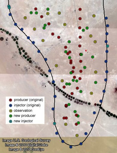
Figure 4. All visible wells which are part of the Haradh-III project (September 2009)
Using a variety of Ghawar well maps, I have determined the numerical identities for many of the wells. These are indicated in the figure below. Five of the observation wells (nos. 3, 27, 28, 41, and 43) were originally vertical wells drilled prior to 1990. Seven additional observation wells (1500-1506) were drilled at the start of the Haradh-III project. Interestingly, two of the "new" wells are actually old vertical well sites, shown as abandoned in 2004 imagery, and now presumably redrilled with horizontal sidetracks. Further confirmation of the identity of these wells as oil producers is the observation that they are connected to the same pipeline network with feeds into the Haradh-III Gas Oil Separation Plant, as shown below with the red traces.
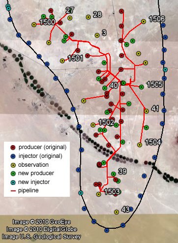
Figure 5. Haradh-III oil pipeline network and identities of several wells
Note that most of the observation wells are also connected to the pipeline network, and wells 3, 27, and 28 are connected to the pipeline network for the Haradh-II GOSP further north.
One detail remaining to be answered is the timing; when, since early 2006, were the additional wells drilled? DigitalGlobe, one of the imagery providers for Google Earth, has mid-2006-2007 images covering most of Haradh, but GE has not made them available at high resolution. However, using the low-resolution previews as overlays indicates that at least five of the new wells were present during that time. One of these, the northernmost new (green) well in the above figures, was seemingly on fire.
Well Done
Shown in the interactive graphic below is the region around a new well seemingly on fire in June of 2006. It was probably in production, as the pipeline to the rest of the Haradh-III network is in place. Move your cursor across the image and left click to view changes in the area from 2004-2009. All of the three producers visible were drilled or flowing at the time of the fire. The 2004 and 2009 images are from high-resolution selections in Google Earth, while the 2006 image is a lower resolution DigitalGlobe image. However, it is still relatively easy to identify changes between the high and low-res cases. Most notable in 2009 is the large number of new gas wells as compared to earlier. This is typical of all of Haradh, as drilling for gas has exceeded that for oil.
Figure 6. One of the added oil producer wells, spewing smoke in June 2006. Mouseover the dates to show 2004 and 2009 views. Click to highlight details.
Mission Accomplished?
With a flurry of rather glowing articles in the press as well as in technical journals, Saudi Aramco has crowned the Haradh-III project a resounding success. These articles are so consistent in their assessment of the project that it was rather surprising to find that it has required 52 producer wells instead of the claimed 32 and also required 3 additional injectors. A couple extra might be expected, but that so many more were needed and that this has not leaked out is somewhat shocking. What are we to infer from this? Lower production from each well (vs. the claim of 10k b/d)? More total production (i.e. over 300k b/d)? My bet is on the former. This certainly doesn't mean that Haradh-III isn't a significant achievement, but this does suggest that the geological complexity still hasn't been overwhelmed by technology. Saudi Aramco has been scrambling since opening day in early 2006 to meet the 300,000 barrels per day production target, and as of last fall, had at least a couple more wells planned.
Finally, I will note that the latest grand achievement by Saudi Aramco, the Khurais field redevelopment, also suffers from well inflation. When first announced, there were to be a total of 310 wells. When finally started up, there were 420 wells. At least they admitted it this time, although no explanation has been offered (perhaps they haven't been asked nicely). Hopefully, Google (GeoEye) will point its new camera at Khurais sometime soon so we may help them count wells.
To browse the well locations using Google Earth, go here.
Commentary: Drawing the lower and upper boundaries of future oil supplyJobless claims reflect weak recovery
No comments:
Post a Comment